


SitySail France app for iPhone and iPad
Developer: Geolives Belgium S.P.R.L.
First release : 27 Jun 2016
App size: 37.52 Mb
SitySail France is a GPS for nautical leisure activities and trails near the coastline in France.
WARNING :
- This application and SCAN Littoral® maps must not be used for boat navigation, otherwise there is a serious risk of injury or death.
- This application only gives access to maps for at least 10 km on both sides of the coastline. If you need a full coverage of France for topographic maps, please download SityTrail France, available on the AppStore.
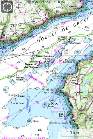
OFFICIAL SCAN LITTORAL MAP
SCAN Littoral® is a common project between SHOM (the French Navy Hydrographic and Oceanographic Service) and IGN (the French National Geographic Institute). It consists of a seamless merging of SHOM’s nautical charts and IGN’s 1:25 000 terrestrial topographic maps.
Coverage is available for France, Corsica and some Overseas departments (Guadeloupe, Martinique, Réunion, Guyane, Mayotte) for at least 10 km on both sides of the coastline.
SCAN Littoral® is useful for trails near the coastline and nautical leisure activities (kayak, …).
Subscription charge: The application can be accessed for free for a week’s trial. You may then take out a subscription for €24.99 per year, all-inclusive.
TOURISM AND DISCOVERY NEAR THE COASTLINE
Discover the new 1:25 000 IGN map ideal to (re)discover an area on foot, bicycle, horseback or car and representing all relevant information for outdoor activities: roads, trails, streams, tourist sites, shelters, rest houses, buildings, religious buildings, ...
The GR ®, maintained by the French Federation of Ramblers, are also displayed! Also shown on the maps are the PR ® (petites randonnées) shorter walks for a day.
MAPS AND YOUR ROUTES AVAILABLE IN OFFLINE MODE
The download tool lets you get the most out of your maps and routes without any internet connection.
There is an alarm when you stray from the route being followed. No more need to continuously check your smartphone, this alarm system will stop you getting lost or having to turn back on yourself.
Automatic activation of points of interest and text to speech synthesis.
An elevation profile that enables the visualisation of inclines and of any difficulties along the route.
RECORD YOUR ROUTES WITH PHOTOS
Record your trails and routes in real time, and create points of interest with your own photos and commentary.
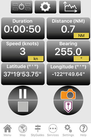
Display useful indicators for walkers and mountain bikers: distance covered, time taken, average speed, GPS altitude, inclines (+/-), ... and information for nautical leisure activities : speeds in knots, distance covered in nautic miles, latitude, longitude, ...
CREATE AND SHARE YOUR ROUTES
With our online editor, create your routes using an internet navigator on your PC/MAC and then accessing them directly from your mobile to experience them on the ground.
Go further. Transform your favourite trails into real multimedia guides with text, photos, video links, and share them with the SityTrail community.
Access too to thousands of walking circuits from other members and let yourself be guided!
TOURIST ATTRACTIONS AND WEATHER SERVICE
Get plenty of localised tourist information: articles Wikipédia, accommodation, restaurants, and various services such as chemists and banks.
Save your favourite places so you can consult them during your trip.
Check on the five-day weather forecast for any location on the map to help you organise your stay.
ADDITIONAL FUNCTIONS
Easily create points of interest, such as the location of your car, your hotel, or a restaurant.
In the event of any problems, the SOS function enables you to send your GPS coordinates to your contacts.
Application Manual: http://www.sitytrail.com/lang-en/manuals_trail.html
For any questions or suggestions: http://www.sitytrail.com/lang-en/support_trail.html
- - -
Some functions need an internet connection.
The prolonged use of GPS can reduce battery levels.